The forecast for the weekend was perfect walking weather, clear skies and cold. I had taken the Friday off from work, and had decided to take advantage of the clear weather and do three days of walking...heaven!
The first day was a trek from Ribblehead, up over Ingleborough via Park Fell (to bag the Trig Point), and down into Horton In Ribblesdale, the Friday however was Friday 13th, which is always a bit in the back of your mind when doing anything, let alone walking an icy path up the side of Ingleborough! But throwing caution to the wind, decided to do it anyway, plus on a day like this, you'd be crazy to miss it because of superstition.
9.8 Miles 4 Hours
I took the first train of the day to Ribblehead, it was pretty quiet, and with the weather so good made the hour and three quarters journey go by quickly. Arriving into Ribblehead at about 10:45am, I stepped out onto the platform to be greeted with the awesome profile of Whernside in the morning sunshine. It's always quite breath taking when you step off the train in the Dales, but on this morning was a great moment...
Looking from Ribblehead Platform towards my objectives, Park Fell, Simon Fell and of course flat topped Ingleborough...
Crossing over the tracks, and following the lane down hill - that leads up to Ribblehead Station, I turned right and onto the B6255. Passing the Station Inn, and adjoining 'bunk barns' you get some great views of the famous Ribblehead Viaduct, with Yorkshire's highest point - Whernside towering above...
After about 300 yards, you need to take the next right (the B6479)...
Walk along the B6479 for a good three quarters of a mile, watching out for the traffic. Here a distant Pen-y-ghent dominates the horizon...
When you reach the three quarter of a mile mark, look out for this small lane cutting off to the right...
Walk up the lane, passing the old railway cottages, cross over a railway bridge. The lane then becomes a farm track...
Old Lime Kiln...
The track passes by the Farm House in the below picture, you then need to pass through a kissing gate that opens out onto open country...
Keeping the below dry stone wall on your left, walk across this quite boggy ground, and up onto the flanks of Park Fell...
On the side of Park Fell now, looking towards Whernside (left) and a distant Wild Boar Fell (on the horizon)...
Climbing up a frosty Park Fell...
This was quite tiring, and it was a welcome relief to see the terrain starting to level out onto the boggy summit of Park Fell...
You have to cross over the dry stone wall here...
Then cross back through it here again via the below gate!...
From the gate its a bit of navigation towards the Trig Point of Park Fell at 563m, with Ingleborough inviting you onwards...
There are posts in the ground marking the route ahead, keep to these...
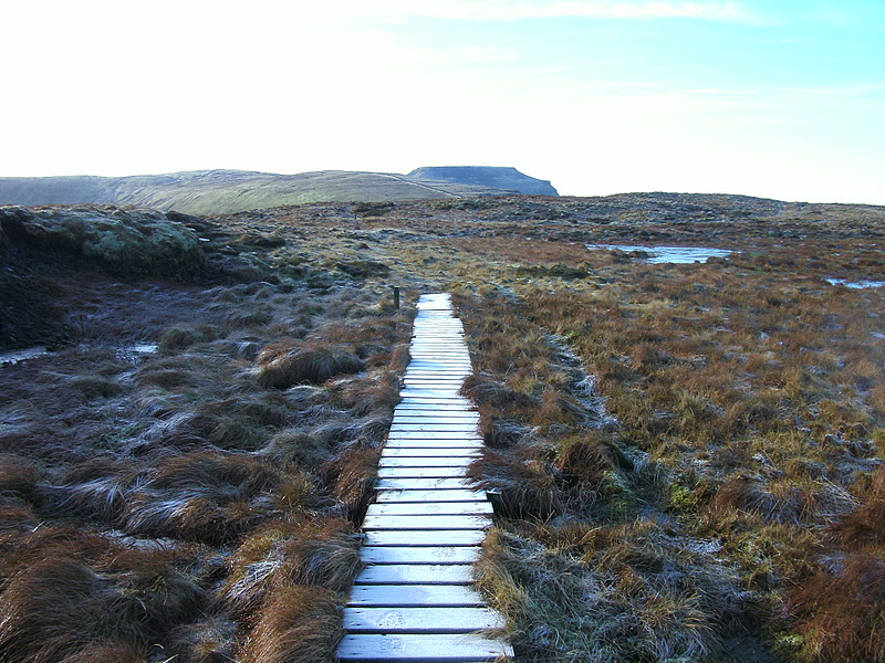
Crossing a frosty board walk..
Following quad bike tyre markings now...
Using my new GPS for this section...
Crossing over a deep peat bog. This was actually particularly tricky to navigate, so watch out here!...
After crossing the bog, you have descended a good one hundred meters or so, a dry stone wall now is to your right. Continue up hill onto the slopes of Simon Fell...
Continue across the edge of 'Top of South House Moor' towards the higher slopes in the below picture..
You will then come to a dry stone wall cutting across the moor, cross over a stile built into the wall and cut right...
At the top of the slope that is Simon Fell, you get to to see a straight forward path leading towards Ingleborough's lower slopes...
Keep the below dry stone wall on your left...
Crossing the boggy, but thankfully frozen ground of Simon Fell...
The path dips a little here, cut right keeping the dry stone wall on your left...
Now cut left again here...
Looking towards Whernside again...
Go through the below gate, take a breather, and then take the rocky steep path towards Ingleborough's summit...
Steep...
A slippy, steep, but well maintained path...
And finally out onto the flat topped summit plateau of Ingleborough...
Cutting south west across the plateau towards the Highest Point...
Ingleborough Summit Trig Point at 723m...
This was particularly special as this was the first time I've been on the summit of Ingleborough, and it's been clear. Awesome views towards the Forest of Bowland, Morcambe Bay, The Lake District (with a snow capped Scafell Pike) and of course the Yorkshire Dales...
A distant Pendle Hill...
A distant Black Combe...
Cut back across the summit plateau to where you ascended. Make your way down until you see the below marker stone, and cut right at it...
The path now continues steeply downwards along the southern edges of Simon Fell, towards Horton In Ribblesdale...
Looking back at Ingleborough...
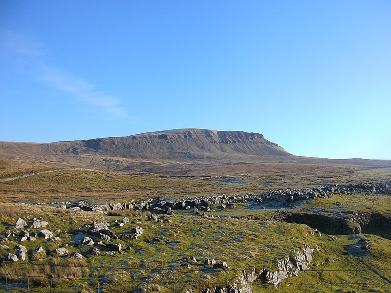
Pen-y-ghent...
Continuing along the easy to follow path...
Keep left here...
The path cuts through the famous Sulber Nick Limestone Pavement...
Always deep mud here...
You will eventually come to this sign post at a cross road. Cut left here...
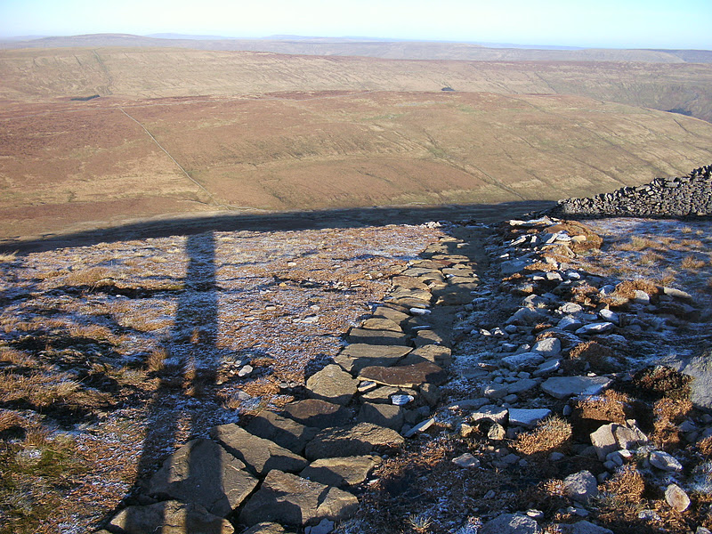
Me and my shadow, continue along this grassy track for a good 400 yards...
Go through this gate, but then cut right across the rough field...
You will have to cross over this gate here, and I ended up making a mistake some where around here, and had to scale a dry stone wall in order to get to a Trig Point that I had sighted on my GPS...
Finding the path again, watch out for the farm house here to get your position...
Scaling yet another gate...
I cut right here, and followed some marker posts in the ground...
I then cut right here again up a steep embankment...
And eventually made it to the Trig Point at 'Sulber' 348m...
The Trig Point in relation to Simon Fell...
From the Trig Point the path heads south across the Limestone Pavement, and eventually meets back up with the path that heads back into Horton In Ribblesdale...
Ingleborough behind Simon Fell, from Sulber Nick...
Simon Fell and Park Fell...
And back onto the main path again...
Horton In Ribblesdale comes into view...
Crossing the tracks at Horton In Ribblesdale Station...
Class 66 (Shed) heads a log train through the station!...
This was a fantastic trek, a nice take your time sort of walk, and I would highly recommend it. I really couldn't have asked for better weather either. An overall great day out in the Yorkshire Dales.
Thanks for reading :0)