There is a saying "you have to move from a place to get to know a place" - apparently. And with my home county of Shropshire this seems to be spot on. There have been a few walks I've drawn up, that when living in the county I wouldn't have even thought about doing. But since moving to Yorkshire I have found many interesting places that were on my door step back then, typically. This walk is certainly in that category, starting in Wales - just about, to scale a high point on the map called Corndon Hill, and then crossing back over the border into a rugged part of Shropshire known as The Stiperstones.
So it was a bus this time from Shrewsbury on a fresh feeling Monday morning, to take me to a remote feeling bus stop on the A488. Then it was a 5 minute walk into the village of White Grit. This tiny village actually straddles the border between Shropshire and Wales, and gets its name from the White Grit Lead that was mined in the area. Indeed, a large stretch of this part of the world had been heavily mined since medieval times, hence some of the unusual village names that are in the area...
And the first high point of the day to scale, Corndon Hill...
Taking this track to the base of the hill, then it's a short steep climb to the summit...
I then took a well walked path south east across Corndon Hill, passing various cairns dotted about its top, then following the path steeply downhill across some scree to the boggy field at the hills base. Here looking back at Corndon Hill...
The path now swings east across farm land back towards the A488. It was a little bit muddy on this day...
And then the heavens opened, as they seem to have done far to often this year...
The lane above adjoins the A488. I walked about 50 yards north back along the A488 before cutting right out onto more sheep filled farm land, following a boggy path north east towards Mucklewick Hill...
The downpour left some heavy cloud on the surrounding hills, here looking towards Black Rhadley Hill on the left, Cefn Gunthly on the right and Heath Mynd sticking up behind...
After crossing Mucklewick Hill, The Stiperstones came back into view...
Following a lane now in the direction of 'The Bog'...
The lane continues for about 3/4 mile before passing The Bog Field Centre. I then followed a lane straight ahead that winds its way steeply upwards to the edge of The Stiperstones. The below Shropshire Way path then cuts left off the lane up out onto the rugged moorland...
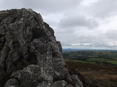
Looking across the heather from the first outcrop, known simply as 'The Rock'...
Things don't get much more rugged than this in Shropshire, this really is a fantastic bit of high moorland, here looking along The Stiperstones towards Cranberry Rock...A now distant looking Corndon Hill from Cranberry Rock...
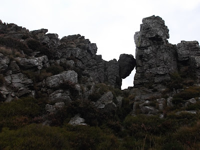
The shattered quartzite scree makes up the impressive tors that adorn The Stiperstones ridge...
Looking north along the ridge...
And looking east towards Pole Bank, the highest point in The Long Mynd...
A distant Wrekin...
Continuing across The Stiperstones...
The ridge path is extremely uneven, a real ankle twister. It's worth leaving yourself plenty of time to cross the ridge...
And finally the summit comes into view, Manstone Rock...
The Trig Point adorns the very top of the outcrop...
A bit of a scramble coming up to get to it...
The Stiperstones summit, 536 metres (1,759ft), and the second highest point in Shropshire...
The first day of October, and the wind certainly felt like it!
Here looking towards the Devil's Chair, back on the ridge path again...
The Devil's Chair is the stuff of legend. Apparently the Devil himself sits up here on the longest night of the year summoning his followers. And again, apparently you can smell the Brimstone on hot days. But to be real, The Devil's Chair is an impressive rocky outcrop that dominates the northern side of The Stiperstones...
After exploring the Devil's Chair another rain storm loomed...
looking towards the tree crowned Bromlow Callow to the west from Perkins Beach...
Here the wide and easier path to walk on continues northwards towards Blakemoorflat...
Looking back towards The Devil's Chair in the gloom...
The moorland starts to give way to fields and woodland beyond Blakemoorflat, here heading through the Hollies looking towards Earl's Hill and Pontesford Hill...
Heading through Maddox's Coppice...
At the edge of Maddox's Coppice, I took a lane left past Bank Farm towards the village of Minsterley. Coming off the lane here heading across farmland towards the village directly...
And finally into Minsterley for the bus back to Shrewsbury...
The Stiperstones are a must visit place for hikers visiting Shropshire, and there are plenty of parking spaces near by for access, and it is entirely possible to do this walk via public transport too. It was nice to bag Corndon Hill though, which has always been inviting when seen from Pole Bank, overall another great Shropshire walk that must be done. Thanks for reading :)


4 comments:
...awesome trek yet again!... ...a quiet whisper: when i see yoU! ~ show up in goOgle reader ~ my kettledrum does a double barrel smile! ~ knowing that it's in for a treat once more! ~ blessed be! ~ dear kindred brother!... ...xXx... ...Samantha... ...hugs to yoU! ~ and the family!...(:
Many thanks Samantha, glad you enjoyed this one. A good trek :)
I like the Stiperstones, it's almost our local hill in Shrewsbury. Even so, during the week, you almost get the place to yourself.
Post a Comment